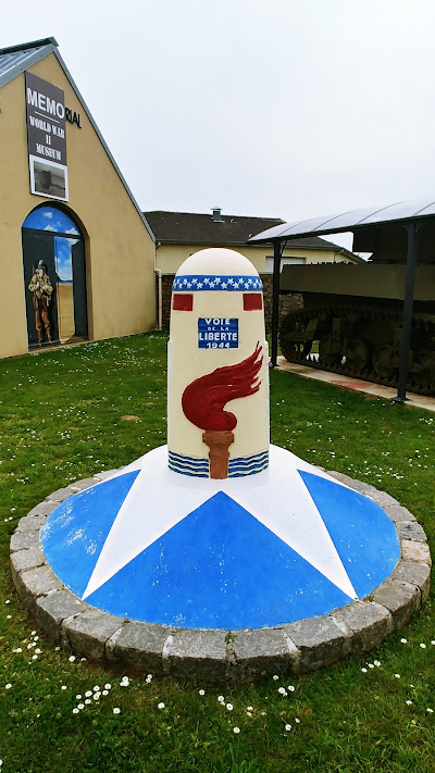
Quinéville WWII Museum Voie de la Liberté Borne
Details:
On the right side of the pathway to the museum.
Marker
The Liberty Road (Voie de la Liberté) is an 1147 km long route commemorating the victory of the Allies and the liberation of France, Belgium, and Luxembourg during World War II. It consists of a series of kilometer markers (or bornes in French) along the road network between Sainte-Mère-Eglise ( terminal 0 ) and Utah Beach ( terminal 00 ) in Normandy, and Bastogne in Belgium, marking the route followed by the US 3rd Army commanded by General Patton during Operation Cobra. The milestones, sculpted by François Cogné, are placed at an interval of 1 km along Liberty Road. ‘’Borne 00 (KM 00)’’ marks the start of the route where the 3rd Army landed.
The Voie de la Liberté was created on the initiative of Major Guy de la Vasselais, a liaison officer with the U.S. Army, and Gabriel Hocquard, Mayor of Metz before and after World War II, with assistance from the Michelin Tire Company. In 1946, they decided to mark the route taken by the Allied troops to liberate Europe with markers, following the example of the Sacred Way of Verdun. The route chosen was that of the 3rd American Army commanded by General George Patton, from its landing on the Cotentin coast to Lorraine. In March 1946, a Belgian association proposed to extend the road to Bastogne (Belgium). Borne 00 marker as well as the one in Sainte-Mère-Eglise were inaugurated on September 16, 1947. The entirety of the road was inaugurated on September 18, 1947, in Fontainebleau (Seine-et-Marne).
Source of photo: www.google.com/maps
Monument Text:
VOIE
DE LA
LIBERTE
1944
English translation:
LIBERTY
ROAD
1944
Commemorates:
Units:
3rd US Army
United States Army
Wars:
WWII
Battles:
Normandy Invasion

